Subscribe to the 100% free rdnewsNOW daily newsletter!
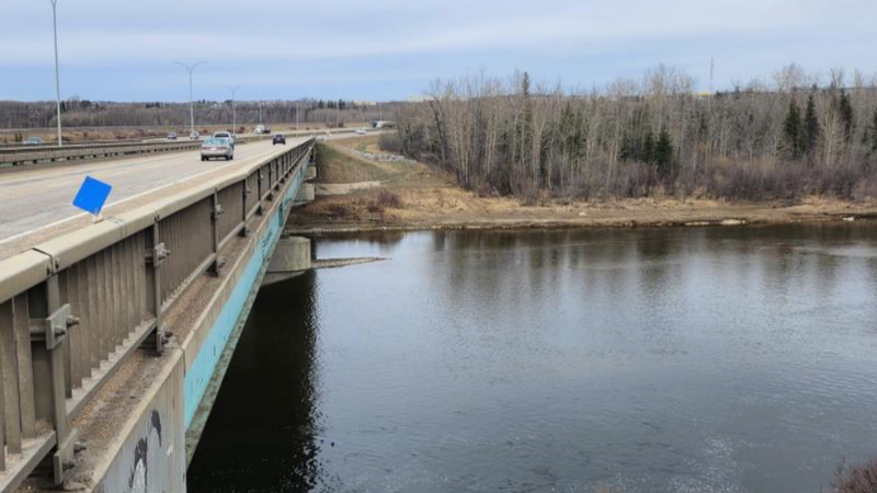
A view north going over one of the 1960s-built bridges which need replacing along the QEII Highway to Red Deer's west, just past Heritage Ranch. This view also looks toward the wetlands and forested area the realigned and widened highway will have to cut through. (Supplied/Gov't of Alberta documents)
'NATURE LOSING OUT TO HUMAN PROGRESS'

Big fuss brewing over highway widening that’ll cut through Red Deer wetlands

Jul 18, 2025 | 2:36 PM

There weren’t enough seats for all the Red Deerians who attended a public info session Tuesday night about the planned widening of the QEII Highway.

As rdnewsNOW reported last week, the Alberta government plans to widen an 11 km stretch of highway through the Red Deer area, from four to eight lanes, but the catch is it would cut through precious and longstanding wetlands at the western edge of Maskepetoon Park — also on the city’s western border.

Government documents suggest the benefits include not just the replacing of 60-year-old infrastructure, but an easing of congestion, and increased safety on a number of fronts.

They also plan to create new wetlands on the opposite side of the highway where the project’s gravel pit would be.

READ MORE: Province wants to double width of QEII Hwy at Red Deer, but would encroach upon sensitive wetlands

But plenty of questions remain, especially if you ask Todd Nivens, executive director at the Waskasoo Environmental Education Society (WEES).

Nivens didn’t attend the meeting, but did represent WEES in the stakeholder consultation step of the government’s process.

“Anytime there’s habitat loss, it’s a concern because of the negative impacts to biodiversity. There are negative impacts to plant cover, with the trees and shrubs that are fantastic carbon removal tools, and they’re one of the best allies we have in climate change mitigation,” he explains, also noting the potential for recreational loss.

“Wetlands are extremely dynamic environments, they are so sensitive and very reactive. The wetlands at Maskepetoon appear to be more stable, in that we don’t see the water level fluctuations, so we’ve got this really healthy community of aquatic plants like cattails, reeds, sedges, pond lilies, and we’ve got the tamarack [tree] fen on the edge of it, all of which are being fed through shallow groundwater.”

No one can know for sure what the long-term impact of the highway widening will have on Maskepetoon Park and its wetlands, he says.

“We might not know for 40 years.”

In a Red Deer context, Nivens notes what’s now known as McKenzie Trails — a beautiful park area towards the city’s north — was also once a gravel pit, the difference being it was not a bustling wetland beforehand.

One concerned citizen is Craig Curtis, who happens to be a former longtime Red Deer city manager.

Curtis did attend the meeting, sharing there were many in attendance who had trouble digesting what was being shared, because they were expected to take in months or even years of research in the matter of an hour.

“[The park] is such a key natural resource in this area, and I recognize we need to replace the bridges. One of the things they could do is try to phase the two bridges. The key is to try and find a balance between the road design and the natural area, and some compromise I think is needed,” said Curtis, who alluded to a similar, and ultimately rejected proposal put forth around 2011.

The bridges he refers to were built in the 1960s.

“I don’t think facilitating higher speed on the highway is necessarily the answer. But what’s needed now is some dialogue with council, and admittedly it comes at an awkward time right before the election.”

Greg Sikora, the City of Red Deer’s parks and public works manager, also attended, and says the city has presented the province with its concerns about cutting through the wetlands.

As he explains, the land is owned by the city, and the city through council has the power to tell the province no. However, it isn’t a full veto, and the province, if it came to this, also has the power go above the city’s head and do it anyway, Sikora says, noting that’s not a prediction.

“If we’re not in favour of the alignment, they could choose to do many things; one being to mothball the project, or they could choose a different alignment with its own pros and cons, or they could choose to expropriate,” he says.

“It depends where it falls on their safety rankings. When we met with the province, they said there are a couple areas along the corridor from Edmonton to Calgary they wish to address, and this is one of them.

rdnewsNOW requested comment from the Ministry of Transportation and Economic Corridors (TEC), including on statistics related to motor vehicle collisions along the stretch in question.

According to the ministry, there were 213 reported incidents on the stretch in question from 2016 to 2025, 22 of which involved injuries.

“Construction will begin on the first phase of the project this year. As design work is still underway for the next steps, Transportation and Economic Corridors will continue to engage with the City of Red Deer through the design process,” Minister Devin Dreeshen says.

“TEC requires the City’s input on various aspects of this project which involve Maskepetoon Park and Heritage Ranch, including acquisition of City-owned lands and options for potential pedestrian/bicycle trail improvements.”

The project’s cost are being determined as design work moves along, the ministry adds.

The ministry, which has studies on water-flow underway, also spoke of the gravel pit to new wetland conversion aspect.

“The conversion of Burnt Lake pit into a natural area has been ongoing for several years. It is approximately twice the size of Maskepetoon Park and contains several large ponds with a total area more than three times the size of the man-made ponds being impacted. The site is located immediately upstream of the highway crossing, to the west of the rail line,” says Dreeshen.

“It is not yet open to the public as a portion of the area is an active gravel pit. The active gravel operations will continue through the duration of the construction project. Once the construction project is complete, the remaining portion of the gravel pit will be reclaimed, completing the conversion to a natural area.”

The Sports Hall of Fame won’t be impacted, other than by construction, and a small portion of Heritage Ranch may be impacted, though the intent is to avoid such things.

Work is expected to take three years.

For Sikora, he says it’s safe to say the city acknowledges the Waskasoo park system and Maskepetoon Park are coveted spaces.

“We also understand we have to work collaboratively. We appreciate the province reached out to the city earlier this year to review the boundary conditions and where they’re confined by the Canadian Pacific Railway to the west.”

Sikora says the city presented three principles to the province for however this should proceed — those being avoidance, mitigation, and finally, compensation. How those will look is yet to be determined.

“This project is going to happen, so I think the message to Alberta Transportation is to tread as lightly as possible, and take as little as possible; be aware that you’re removing and disturbing a resource that’s existed longer than we’ve been here,” Nivens added.

“Maskepetoon Park is a pretty special place. When I first learned of this, I was disappointed to see that, once again, habitat, nature and the environment is taking a back seat to human progress.”

More on the project is here.