Local news delivered daily to your email inbox. Subscribe for FREE to the rdnewsNOW newsletter.

Rivers recede as B.C. faces prospect of ‘unfamiliar territory’ for drought

May 9, 2024 | 2:03 AM

Parts of British Columbia will likely enter “unfamiliar territory” with drought if they see another hot, dry summer, says the head of the province’s River Forecast Centre.

Dave Campbell says persistent drought conditions in B.C. stretch back to 2022, so the province is heading into this summer with “multi-year” precipitation deficits.

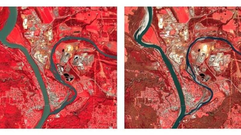
Satellite photos show rivers across the province running narrower and shallower than the same time in 2023, which went on to be one of B.C.’s driest years on record.

With average snowpack levels lower than ever recorded in B.C. this past winter, Campbell says he’s expecting cumulative effects that could include water scarcity and other challenges.

“We know these antecedent conditions that we’re coming into this year are much more challenging than we started out last year with,” he said in a recent interview.

“The concern obviously is if we get that hot, prolonged dry (period) that we’ve seen last year and the year before as well. If that continues this summer, then really we are on a path toward things that we haven’t seen in recent memory.”

Pockets of the Interior are especially dry. Campbell said he’s most worried about the effects of drought on smaller rivers and creeks in the central Interior.

“Prince George, Quesnel, Williams Lake, Vanderhoof, that’s kind of the hot spot, and then the other (area) that would be a concern would be up in the northeast,” he said.

The area around Vanderhoof, B.C., west of Prince George, has seen about 220 millimetres of rain over the past year when it typically sees about 460 millimetres, he said.

Images provided by the Canadian Space Agency appear to show the effects of persistent drought in the Interior when compared with those taken last spring.

An image taken last week by theEuropean Space Agency’s Sentinel-2 satellite shows the Quesnel River is narrower, with more of its banks exposed this month compared with an image taken a year ago. Last week’s photo shows patches of exposed riverbed and sandbars, indicating lower water levels in the tributary as it meets the upper Fraser River in Quesnel.

Satellite images tell a similar story in Fort St. James, B.C., where the water appears shallower this year as Stuart Lake feeds into Stuart River.

The Fort Nelson and Muskwa rivers also appear narrower, with more of their banks exposed compared with images taken in April 2023.

The Canadian Space Agency notes the images use infrared “false colour” because it shows the boundaries between land and water more clearly than other renditions.

Campbell said parts of B.C.’s Okanagan will likely also see the effects of the moisture deficit and low amounts of snow that melted early this spring.

On northern Vancouver Island, meanwhile, he said the community of Port Hardy, B.C., has seen 1,260 millimetres of rain over the last year when it typically sees a little more than 1,800 millimetres.

It would take “a few months of wet-season rainfall” to ease the drought, he said.

B.C.’s snow survey last month found snowpack across the province was “extremely low,” averaging 63 per cent of normal. The Quesnel area was listed at 52 per cent of normal, while the neighbouring West-Road Chilcotin region was at zero per cent.

Officials are expected to hold a press conference about drought and wildfires on Thursday as the province releases its latest snowpack bulletin.

This report by The Canadian Press was first published May 9, 2024.

Brenna Owen, The Canadian Press