Local news delivered daily to your email inbox. Subscribe for FREE to the rdnewsNOW newsletter.
Hail spotted near Innisfail on Aug. 1, 2022. (Submitted)
UPDATED Aug.3, 2022

Up to softball-sized hail reported in Markerville and Innisfail areas during August 1st storm

Aug 2, 2022 | 12:49 PM

Fortunately there are no reports of injuries so far following an active day of severe weather in many parts of central Alberta on Monday.

According to Environment and Climate Change Canada, reports of a possible tornado originating in Clearwater County, first came in at 2:17 p.m., with the storm tracking it’s way east and southeast throughout the afternoon and into the evening.

Jesse Wagar, Meteorologist, Environment and Climate Change Canada, says the storms began along the foothills as they often do in Alberta.

“We had several thunderstorm watches and warnings, as well as tornado watches and warnings issued for that time frame,” says Wagar. “Conditions were certainly favourable for the development of dangerous, rotating thunderstorms and tornadoes. We did have some funnel cloud reports with storms near Rocky Mountain House and Spruceview, but at this time, we’ve seen nothing that would indicate that a tornado had in fact touched down.”

Wagar notes, however, very damaging hail reported with the storms.

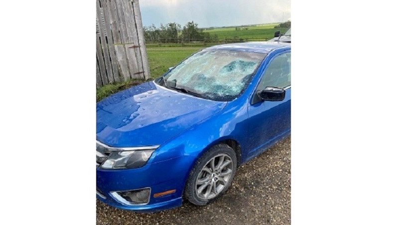
“There was damage to cars, up to softball-sized hail near Markerville,” adds Wagar. “That’s 10 centimetres-wide hail which is incredibly large. Then baseball to tennis ball-sized hail reported near Innisfail and over the QEll in that area. Looks like some cars were unfortunately in the wrong place at the wrong time and sustained quite a bit of damage.”

(Supplied)
Four-year-old Penhold resident Freya Dutkiewicz holds a sizeable piece of hail that fell during a Tornado-warned storm on Aug. 1, 2022. (Submitted)
Hail damage near Innisfail from the Aug. 1, 2022 storm. (Submitted)

According to Environment and Climate Change Canada, Markerville saw softball-sized hail up to 10.6 cm, with Innisfail and Milnerton reporting baseball-sized hail of 7.5 cm.

Elsewhere:

Penhold: Tennis ball (6.4 cm)

Sylvan Lake: Tennis ball (6.4 cm)

Wimborne: Tennis ball (6.4 cm)

Condor: Hen egg (5.5 cm)

Pine Lake: Golf ball (4.5 cm)

Lacombe: Nickel (2.1 cm)

Ponoka: Nickel (2.1 cm)

Red Deer: Nickel (2.1 cm)

Rimbey: Nickel (2.1 cm)

Rocky Mountain House: Nickel (2.1 cm)

Later on in the evening as the storms moved east and southeast, Wagar says they transitioned from a tornado threat to more of a generalized wind threat.

“Then we saw those storms move through the Trochu area where there was some wind damage reported there,” shares Wagar. “Wind speeds themselves were measured near 90 km/hr. However, Doppler radar would indicate that the winds were likely a bit stronger than that. Probably closer to the 110 km/hr mark.”

According to Environment and Climate Change Canada, nearby Three Hills reported wind speeds of up to 119 km/hr.

As for Red Deer itself, Wagar says the city saw between 20-25 mm of rain during the storms.

“Hail and prolific lightning, and of course, the tornado threat were the main hazards with yesterday’s storm,” she explains. “They weren’t really heavy raining type storms, but definitely the hail, the lightning, and again, the tornado threat and the winds of course too.”

Wagar says it’s important to remember that these types of storms are not uncommon in Alberta during the summer, so she encourages residents to always stay ‘weather aware’.

“Have a way to receive those alerts and know what to do to keep yourself safe when you do receive those alerts,” she exclaims.